
 |
| There's no better proof that 'Eelamism' was a British creation than the fact that the 'Eelam Map' is a trace of arbitrary lines drawn by the British. |
On many occasions when the issue of ‘homelands’ (traditional ones, that is) have come up, I have made the following observation: the current provincial boundaries (which are the basis for the Tamil chauvinists’ claims and demands for forms of regional autonomy ranging from augmentation of the 13thAmendment to a federal arrangement and to even a separate state) are lines arbitrarily drawn by some white man even as he played his part in the plunder of the island’s resources, exploitation of her people, vandalizing of places of religious worship, and the systematic destruction and/or theft of her cultural artifacts.
The entire discourse of the ethnic-conflict, so-called, has been about alleged grievances. It has also been about inflating these and perhaps because even with inflation the devolution ‘solution’ is so weak, grievances (alleged) have been coupled with aspirations. Nothing wrong in this. It’s politics. It’s about using available resources (which include the facilities of deceit and threat) for self-improvement, either of the community (in the nobler manifestations) or a few individual articulators (as is more common). What’s wrong is the chest-beating indignation and self-righteousness.
They all get tripped on multiple counts, these defenders of fictions, justifiers of land-grabbing intent and rhetoricians adept at painting myth as history and fiction as fact, but perhaps nothing induces blush more than the following two questions. First, is there any community of the same size (proportionally) with the same sparse substantiation of claims, with a track record of brinkmanship, tacit and even open approval of terrorism, anywhere in the world that has married provable grievance to reasonable aspiration and demanded the delivery of the kind of baby that Tamil nationalists have asked for? Then there is the vexed question of boundaries alluded to above. That’s a real bummer, the Americans of the USA who have for reasons that are not too obscure supported such moves, might say.
Someone would have drawn the ‘Eelam Map’ which is the most prominent element in the flag used by the LTTE and LTTE sympathizers. From what history were those lines obtained? Where in the Tamil chauvinist narrative is there reference to any historical account of any credibility that has even a footnote on the boundaries that mark the homeland that is said to be traditional (or historical, as some prefer)?
C.V. Wigneswaran, poor man, struggling for political relevance and therefore preying on innocent aspirations and playing with nationalist rhetoric, talks of a looooong Tamil history. Strange, isn’t it, that in this looooong and splendid history those who came before didn’t leave any significant mark of their passing and their alleged glory? Where are the chronicles? Where are the artifacts? Where are the Tamil Buddhist texts if as some say the Buddhist archaeological remains in the North and East are remnants of ‘Tamil Buddhism’? Most importantly, where the devil are the lines, the boundaries, those itty-bitty things that are essential for any kind of cartography?
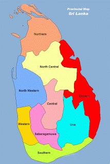
The island is divided into 9 provinces. The divisions were expressly made for administrative convenience. They were created in 1890 during the reign of Queen Victoria. Before they were drawn the island was divided into five provinces. That was in 1833 during the reign of King Willing IV. The division was made by the British colonial powers. Again for administrative convenience. And long before that, we had the Ruhunu, Maya and Pihiti, the ‘thun sinhale’ as in the three provinces of the political entity known as ‘Sinhale’, the name obtained from two words, ‘Siv’ (four) and ‘Helas’ (Yaksha, Naga, Raksha and Deva).
Where are the ‘old’ maps of that looooooooong ago, Mr Wigneswaran? Who drew the more recent map, i.e. the one with 9 provinces and what was the logic that drove the cartographer, Mr Wigneswaran? Well, it’s a question that all devolution-supporters will have to answer if they believe the creative Eelamist historiography touted by Tamil nationalists from at least the time of Ponnambalam Ramanathan.
They can refuse to answer of course (as they usually do), except for a tiny little irritant. President Maithripala Sirisena has raised the issue of map-making. Mangala Samaraweera, Rajitha Senaratne, Dilan Perera and other purchases of Eelamist nonsense cannot ignore the President’s contention. President Sirisena got the name of the monarch wrong of course, but that’s just an unimportant detail. What matters is that Maithripala Sirisena said that it was the British who drew what later turned out to be the ‘source’ of the Eelam map that the likes of Wigneswaran (and before him Prabhakaran, A Amirthalingam, GG Ponnambalam and SJV Chelvanayakam) love to wave. Now that (i.e. 1890) is certainly not loooooooong ago, is it?
Maithripala Sirisena is the first president (to my knowledge) who came out and said it as it is. He said what politicians of all ideological persuasions in the major political parties have dodged for one reason or the other (except of course the Sinhala nationalists). Let’s leave Wigneswaran out of it. He’s doing a bread and butter operation. Understandable. What does the UNP and the JVP have to say now? What do the bleeding heart liberals in academe and in the NGO business have to say? And how about the Government of Switzerland which believes Sri Lanka got a new constitution? How about Eric Solheim and the Kingdom of Norway? Oh, I almost forgot. Will the British High Commission care to comment?
The President has spoken, ladies and gentlemen. And he’s not Mahinda Rajapaksa, the ‘hawk’, the ‘war monger’, the ‘Sinhala majoritarian, chauvinistic autocrat’. He is none other than Maithripala Sirisena. The unifier. The good governance hero. He’s said something that had to be said. He has thrown the gauntlet. Any takers out there?
Malinda Seneviratne is a freelance writer. Email: malindasenevi@gmail.com. Twitter: malindasene.
6 comments:
We all know it was the British who did it to divide Our country on ethnic grounds though they have not called it the EELAM .They called it the TAmil Home land They brought Malbar Indians and settled them all over and did everything and created an English Educated TAmil elete with the assistance of American missions particularly in the North and the EAst.possible to create this mental syndrome among the so-called Tamils in addition to Estate Tamils
When and where and at what occasion he (MS) said this?
at 42nd national sports festival, jaffna. a few days ago.
Sudath you are hundred percent correct
Going further back ,before the period of British Colonial rule ,even beyond all western colonial invasions history confirms the existence of a Jaffna kingdom that incorporated Vanni and the eastern zones .It is always good to quote the whole truth and not pick out events that conveniently support ones own view point.
Cite your source, please. :)
Where are the ‘old’ maps of that looooooooong ago, Mr Wigneswaran? //
I am not really familiar with this 'Mr Wigneswaran', but is it possible he was referring to this map: https://www.google.co.uk/search?q=dutch+ceylon&dcr=0&tbm=isch&source=iu&pf=m&ictx=1&fir=bqUvakdGADIHuM%253A%252Cw-tY8WgwgGVyTM%252C_&usg=__k0HWfCz8_ylwIFEPvRDN4QCScdk%3D&sa=X&ved=0ahUKEwiRubef-uHWAhWWOsAKHTWLD1EQ_h0IfzAO#imgrc=bqUvakdGADIHuM:
The map is of Dutch Ceylon (1640-1796). The boundaries lined by green look uncannily similar to the ones used by Eelamists.
Post a Comment